This website uses cookies. To read more about them, click 'cookies stored'. To accept our cookies, click the check box then press 'Continue'.

| Us |
|
|
Parishes |
|
Websites |
|
On |
|
Our archive and search room is now open on Tuesdays and Thursdays from 10am to 4pm. Keep up to date via our Facebook page and Twitter.
|
The quoad sacra Parish of Caddonfoot which comprises part of the former Parishes of Galashiels, Innerleithen, Selkirk, Stow and Yarrow is bounded on the north by the County of Midlothian, on the east by the Parish of Galashiels, on the south by the Parishes of Selkirk and Yarrow and on the west by the Parishes of Innerleithen and Traquair. Previously partly in the County of Midlothian and partly in the County of Peebles, Caddonfoot existed as an administrative unit from 1898 to 1975. The ecclesiastical parish of Caddonfoot is now linked with Galashiels Trinity Sales List
See our sales list for full details and cost of postage. |
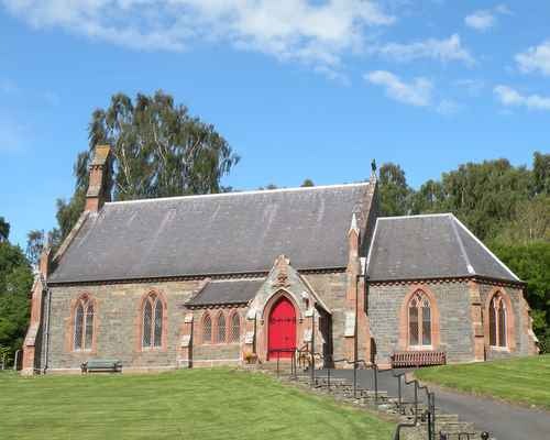
Caddonfoot Church
 |
Please note that the heading Author includes persons who have compiled or transcribed records; and that the topics indexed, and the synopses are subjective opinions.
See the Sales List to buy copies of the magazines containing articles in which you're interested.
| Title | Synopsis | Size Description | Issue No | Author |
|---|---|---|---|---|
| From Cowal to the Borders. Internal migration of the Whyte Family | The Agricultural migration of workers and the history of the Whyte Family. | 2 pages or more | 7 | Donald Whyte |
| Laidlawstiel, Clovenfords | This is history bought to life with Walter Scott, William Wordsworth and Prime Minister Gladstone. For anyone interested in Clovenfords you must read this. | 2 pages or more | 37 | Margaret Lawson |
Map of Caddonfoot from UK Great Britain, Ordnance Survey one-inch to the mile (1:63,360), 'Hills' edition, 1885-1903
by kind permission of the National Library of Scotland.
Use the control at the top left of the map to zoom in or out and drag the map left, right, up, or down as you wish.
Map of Caddonfoot from UK Ordnance Survey Historical Maps from 1919-1947
by kind permission of the National Library of Scotland.
Use the control at the top left of the map to zoom in or out and drag the map left, right, up, or down as you wish.
The population has been recorded as follows: 1867 - 693.
Selkirkshire map