Langton is a centrally situated Parish in the County of Berwick being bounded on the north by the Parish of Duns, on the east by the Parishes of Edrom, and Polwarth,
on the south by the Parishes of Polwarth and Longformacus and on the west by the Parish of Longformacus.
Old Parish Birth Records exist from 1728 to 1854.
Marriage Records from 1730 to 1775 and from 1821 to 1854. Death records exist from 1731 to 1773.
1841 census Langton.
1851 census Langton.
1861 census Langton.
The Society has not as yet recorded the Langton Memorial Inscriptions although a copy done privately is available in our Archive.
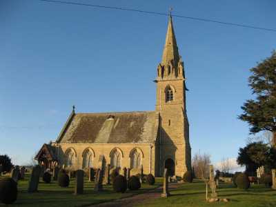
Langton Parish Church
See our sales list for full details and cost of postage.
Volumes available for consultation within our Archive
Memorial Inscription Gavinton Churchyard.
Pre 1855 Memorial inscriptions of Berwickshire by David Cargill.
The Churches and Churchyards of Berwickshire by G.A.C. Binnie.
C.D. The Churches and Churchyards of Berwickshire by James Robson 1896.
Index to Particular Register of Sasines for Berwickshire.
Pigot's 1837 Directory of Berwickshire and Roxburghshire.
Rutherford's Southern Counties Register and Directory 1867.
C.D. Slater's Director of Berwickshire 1903.
County Directory of Scotland 1912 - Borders Towns and Villages.
Magazine Articles;
Please note that the heading Author includes persons who have compiled or transcribed records; and that the topics indexed, and the synopses are subjective opinions. See the Sales List to buy copies of the magazines containing articles in which you're interested.
Title
Synopsis
Size Description
Issue No
Author
Cockburns of that ilk
The origins of Cockburns in Berwickshire
3 pages or more
36
Russell Wilson Cockburn
Rev. Dr. John Brown, Langton
Notes and background information on the Rev. John Brown, minister at Langton and his son Thomas Brown author of 'Annals of the Disruption'.
less than 1 page
98
Map of Langton from UK Great Britain, Ordnance Survey one-inch to the mile (1:63,360), 'Hills' edition, 1885-1903 by kind permission of the National Library of Scotland. Use the control at the top left of the map to zoom in or out and drag the map left, right, up, or down as you wish.
Map of Langton from UK Ordnance Survey Historical Maps from 1919-1947 by kind permission of the National Library of Scotland. Use the control at the top left of the map to zoom in or out and drag the map left, right, up, or down as you wish.
Other Records;
Life at Langton Village by Laurie Cleat and Isobel McLelland 1999.
Scottish Borders Archives and Family History Centre, The Hub Hawick hold the following records;
School Board Minute Book 1873 to 1919 ref; B/ED/1/64-65.
School Log Books 1921 to 1965 ref; B/ED/2/28-29.
The Scottish National Archives Edinburgh hold the following:
Langton Parish Church;
Minutes 1727 to 1783 - ref; CH2/980.
Langton Free Church;
Baptismal Records 1849 to 1924.
Minutes 1850 to 1927.
Communion Roll 1844 to 1927.
Deacons' Court Minutes 1844 - ref; CH3 1521.
Berwickshire Naturalists' Club has published the following articles
Vol. 13 Rent Roll in 1756.
Vol. 14 Langton - its owners.
Vol. 28 Woolfordland on Borthwick Hill.
Vol. 29 Cockburns of Langton.
Vol. 36 Ministers of the 17th. century.
Vol. 41 Langton Parish School.
Vol. 43 Langton Parish by Kathleen B Fleming (available in Society Archives).
Vol. 44 Sir Archibald Cockburn 2nd. Baronet of Langton by L.H. Cleat - (available in
Society Archives).
Vol. 47 Castles of the Cockburns by L.H. Cleat, contains a history
of Langton Castle, Cockburn Tower, Borthwick Castle and Langton Tower -
(available in Society Archives).
Vol. 47 Langton Parish, Gavinton and Raecleugh Head by Isobel McLelland (available in Society Archive).
Websites
Dunse History Society holds Articles of Roup and various records and
photographs relating to Langton House also various photographs of Gavinton Village.