Our archive and search room is now open on Tuesdays and Thursdays from 10am to 4pm. Keep up to date via our Facebook page and Twitter.
Lyne & Megget (St Mary's)
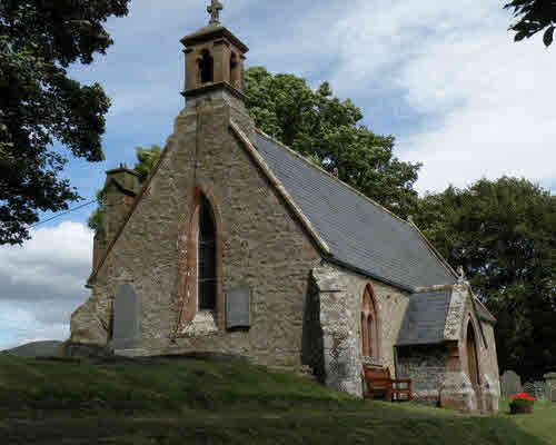
Lyne is a small parish in the County of Peebles lying just to the west of the county town. It is bounded on the north by Eddleston with Peebles to the east, Stobo to the south and Newlands on the west. Lyne Water runs through the parish and the main settlement is around the disused station on the former Caledonian Railway line to Peebles. The church is about a mile away on a slight rise to the north of the A72. There are the remains of a Roman Fort near Lyne Water. Megget is united with Lyne, although they have no common border. They now form part of the combined parish of Lyne & Manor although yet again the two parishes don't share a boundary.
Megget is located on the southern edge of Peeblesshire on the border with Selkirkshire and Dumfriesshire. There is no longer a church but the ruins of St Mary's Kirkyard can be seen near the western end of St Mary's Loch.
Old Parish Records cover the periods:
Births: 1649-1854 (Mothers' names are rarely recorded until 1788)
Parish of Lyne and Megget Deaths 1840-1856 by Nigel Hardie
See our sales list for full details and cost of postage.
Volumes available for consultation within our Archive
A Living Village by Andrew Fox, Elmbank Printing Services
County Directory of Scotland 1912 - Borders Towns and Villages
Extracts from the Records of the Burgh of Peebles 1652 to 1716 (CD)
Lyne and Megget Burial Records 1840 to 1854 as compiled by the Society
Pre 1855 Monumental Inscriptions of Peeblesshire
Rutherford's Southern Counties Register and Directory 1867
The Source of Manor
Magazine Articles
Please note that the heading Author includes persons who have compiled or transcribed records; and that the topics indexed, and the synopses are subjective opinions. See the Sales List to buy copies of the magazines containing articles in which you're interested.
Title
Synopsis
Size Description
Issue No
Author
Lyne , Megget and Manor Monumental Inscriptions
Some notes on the CD of Monumental Inscriptions and other records of Lyne, Megget and Manor, published by the Society.
1 page or more
88
Map of Lyne from UK Great Britain, Ordnance Survey one-inch to the mile (1:63,360), 'Hills' edition, 1885-1903 by kind permission of the National Library of Scotland. Use the control at the top left of the map to zoom in or out and drag the map left, right, up, or down as you wish.
Map of Lyne from UK Ordnance Survey Historical Maps from 1919-1947 by kind permission of the National Library of Scotland. Use the control at the top left of the map to zoom in or out and drag the map left, right, up, or down as you wish.
20 Most Common Surnames
The 20 most common surnames on gravestones recorded by us in the Lyne, Megget & Manor monumental inscriptions volume are (number of gravestones in brackets): BURNETT (27), ANDERSON (19), HORSBURGH (18), RITCHIE (17), MITCHELL (16), TOD (15), SCOTT (13), MELROSE (13), JOHNSTON (13), STEWART (13), SMITH (12), TODD (12), PROUDFOOT (11), GRAY (11), LITTLE (10), VEITCH (10), WILSON (9), THOMSON (9), TAIT (8), BROWN (8).
20 Most Common Surnames
The 20 most common surnames on gravestones recorded by us in Lyne Churchyard in the Lyne, Megget & Manor monumental inscriptions volume are (number of gravestones in brackets): SMITH (9), GRAY (8), TAGGART (7), VEITCH (6), STEWART (5), WHITE (5), CAMPBELL (4), ANDERSON (3), BRODIE (3), HUNTER (3), PORTIOUS (3), TOD (3), BROWN (2), GILCHRIST (2), JEFFREY (2), JOHNSTON (2), KERR (2), PATERSON (2), WALES (2), WALKINSHAW (2).
Other Sources
A History of Peeblesshire (3 Vol) - Buchan & Paton, Jackson, Wylie and Co, Glasgow 1925-7
Lyne Kirk, Peebles, Monumental Inscriptions by Scottish Monumental Inscriptions
The Buildings of Scotland - Borders, Cruft, Dunbar & Fawcett, Yale University Press, London 2006
The Statistical Accounts of Scotland compiled initially between 1791 and 1799, with a subsequent edition between 1834 and 1845 are a valuable record of the geography, history, economy, people and customs recorded by local ministers. You'll need to search for the parish name
The National Archives of Scotland
Lyne kirk session records (Ref - CH2/255)
Accounts 1846-1950
Minutes 1649-1682, 1852-1951
Minutes, Collections, etc. 1834-1838 - few leaves
Miscellaneous Records 1726-1780
Berwickshire Naturalists' Club has published the following articles