Our archive and search room is now open on Tuesdays and Thursdays from 10am to 4pm. Keep up to date via our Facebook page and Twitter.
Newlands
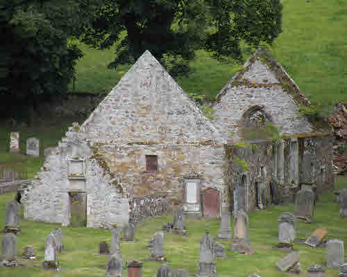
Newlands parish is in the north of Peeblesshire on the border with Midlothian. It is bounded on the east by Eddleston. Kirkurd, Stobo and Lyne are to to the south and West Linton to the west. The church is on the banks of Lyne Water with few houses in the immediate vicinity. The present building was erected in 1838. The ruins of the original Saxon & Gothic church are close by. The parish war memorial is on the wall of the church. Drochil Castle, which dates from the late 16th century stands above the junction of Lyne Water and Tarth Water.
St Andrews, West Linton Church is a Church of Scotland congregation linked with the churches of Kirkurd and Newlands.
Old Parish Records cover the periods:
Births: 1661-1854 (Mothers' names are not recorded until about 1809)
Parish of Newlands Mortcloth Records 1709-1759 by Nigel Hardie.
See our sales list for full details and cost of postage.
Volumes available for consultation within our Archive
County Directory of Scotland 1912 - Borders Towns and Villages
Extracts from the Records of the Burgh of Peebles 1652-1716
Pre 1855 Monumental Inscriptions of Peeblesshire by S.A. Scott published by Scottish Genealogical Society 1971
Rutherford's Southern Counties Register and Directory 1867
Magazine Articles
Please note that the heading Author includes persons who have compiled or transcribed records; and that the topics indexed, and the synopses are subjective opinions. See the Sales List to buy copies of the magazines containing articles in which you're interested.
Title
Synopsis
Size Description
Issue No
Author
Newlands Communion Tokens
Based on information from George Ainslie. A description and photographs of communion tokens from his collection from United Presbyterian Churches, Newlands parish.
1 page or more
104
Editor
Two stories of 19th century emigration to Australia and New Zealand
Two stories from the 19th century of emigration to the New World; Andrew Rutherford and his family.
less than 1 page
12
Elsie Ahrens
Map of Newlands from UK Great Britain, Ordnance Survey one-inch to the mile (1:63,360), 'Hills' edition, 1885-1903 by kind permission of the National Library of Scotland. Use the control at the top left of the map to zoom in or out and drag the map left, right, up, or down as you wish.
Map of Newlands from UK Ordnance Survey Historical Maps from 1919-1947 by kind permission of the National Library of Scotland. Use the control at the top left of the map to zoom in or out and drag the map left, right, up, or down as you wish.
Other Sources
A Brief Chronicle of Old and New Churches of Newlands and its Ministers, by Bertie Patterson
A History of Peeblesshire (3 Vol) - Buchan & Paton, Jackson, Wylie and Co 1925-7
Annals and Statistics of the United Presbyterian Church, by Rev William MacKelvie
The Buildings of Scotland - Borders, Cruft, Dunbar & Fawcett, 2006
The Statistical Accounts of Scotland compiled initially between 1791 and 1799, with a subsequent edition between 1834 and 1845 are a valuable record of the geography, history, economy, people and customs recorded by local ministers. You'll need to search for the parish name.
Newlands Public School Log Book, 1874-1921; ref: P/ED/2/27
The National Archives of Scotland
Newlands kirk session records (Ref - CH2/543)
Accounts 1709-1759, 1850-1893
Heritors' Minutes 1790-1832, 1836-1927
Minutes 1650-1694
Papers Concerning Kirk Session and Heritors 1754-184
Newlands United Presbyterian Church records (Ref - CH3/373)
When an unpopular minister was settled in 1791, some parish members left the Established Church and obtained supply of sermon from the Relief Presbytery of Edinburgh and built a church in 1793.