Our archive and search room is now open on Tuesdays and Thursdays from 10am to 4pm. Keep up to date via our Facebook page and Twitter.
Coldingham
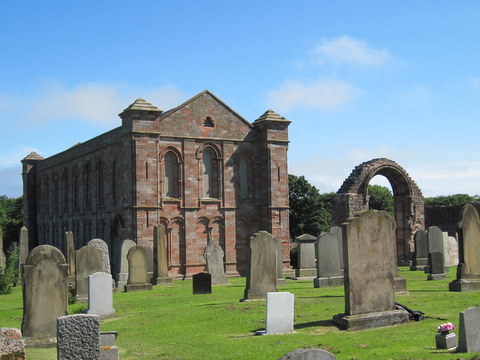
Coldingham, the largest Parish in Berwickshire, is situated in the north east of the County, being bounded on the east by the North Sea, on the south by the Parishes of Eyemouth, Ayton and Chirnside, and on the west by the Parishes of Bunkle, Abbey St. Bathans and the Parish of Cockburnspath to the north.
Coldingham Monumental Inscriptions CD includes photographs of gravestones, Hearth Tax, Militia List, Militia Families Vouchers, War Memorials and Rolls of Honour.
CD-ROM Monumental Inscriptions Houndwood transcribed by Frank and Helen Richardson' includes:
List of Ministers
War Memorial transcription
We are currently involved with the Friends of Coldingham Priory in the recording of the gravestone inscriptions.
See our sales list for full details and cost of postage.
Volumes available for consultation within our Archive
Callants' Capers at St. Abbs by Will Hood (The Southern Annual, 1961).
CD Land Ownership Commission Report 1872 -1873.
CD Slater's Directory of Berwickshire 1903.
CD The John Wood Collection (a collection of 100 photographs of Coldingham and surrounding area taken between 1890 and 1910).
Coldingham Miscellaneous Papers published by Lothians Family History Society.
Coldingham Mortcloth Records 1694-1759 by Vivienne S Dunstan 1998.
Coldingham Priory by T.D. Thomson 1981.
County Directory of Scotland 1912 - Borders Towns and Villages.
Down Memory Lane - by gone days at St. Abbs by Will Hood (The Southern Annual, 1952).
Index to Particular Register of Sasines for Berwickshire.
Lady Helen Hall by Sally Wilson
Old Coldingham and St. Abbs by Lawson Wood.
Pigot's 1837 Directory of Berwickshire and Roxburghshire.
Pre 1855 Memorial Inscriptions of Berwickshire by David Cargill.
Rutherford's Southern Counties Register and Directory 1867.
CD The Churches and Churchyards of Berwickshire by James Robson 1896.
The Churches and Churchyards of Berwickshire by G A C Binnie.
The Seat at the top of the brae - boyhood days in St. Abbs by Will Hood (The Southern Annual, 1965).
William Crow of Netherbyres (c1704-1750) a sketch of his life and work (Berwickshire Naturalist Club, Vol. 44)
Magazine Articles
Please note that the heading Author includes persons who have compiled or transcribed records; and that the topics indexed, and the synopses are subjective opinions. See the Sales List to buy copies of the magazines containing articles in which you're interested.
Title
Synopsis
Size Description
Issue No
Author
Coldingham mortcloth records
The mortcloth records are fascinating as they list every occasion when a mortcloth was hired out for a burial. This covers the Coldingham mortcloth.
1 page or more
28
Vivienne S. Dunstan
Liddles Abroad
Family pictures awaken an interest in family history. The author made contact with relatives in Australia, descendants of a blacksmith who'd emigrated front Heughhead, Reston.
2 pages or more
72
Bill Stewart
Coldingham Monumental Inscriptions
A report of the Society's publication on CD. of the Monumental Inscriptions in Coldingham Priory with some additional information.
1 page or more
78
Elma Fleming
A Fortunate Experience at Coldingham
Discovering a family grave in the churchyard at Coldingham Priory.
1 page or more
89
Ian Blackie
Grantshouse and the Turner family
The history of Grantshouse and one of its sons, James Turner. Continued in issue 28.
3 pages or more
27
James Burns
The Aytons of Ayton
The parish of Ayton from the Norman family De Vesci who changed their name to Ayton to a history of the village.
2 pages or more
17
James Eaton
From Coldstream to Canada
The Galbraith history from Coldstream to Toronto University. A comprehensive account of the Galbraiths.
3 pages or more
26
James Burns
The Bradford Family Search
A tale of family that moved from Northumberland to Berwickshire. All were farm servants some labourers some farm stewards. There are irregular marriages, name changes and a possible pioneering birth using chloroform.
6 pages or more
72
Bill Bradford
Map of Coldingham from UK Great Britain, Ordnance Survey one-inch to the mile (1:63,360), 'Hills' edition, 1885-1903 by kind permission of the National Library of Scotland. Use the control at the top left of the map to zoom in or out and drag the map left, right, up, or down as you wish.
Map of Coldingham from UK Ordnance Survey Historical Maps from 1919-1947 by kind permission of the National Library of Scotland. Use the control at the top left of the map to zoom in or out and drag the map left, right, up, or down as you wish.
20 Most Common Surnames
The 20 most common surnames on gravestones recorded by us in the Coldingham monumental inscriptions volume are (number of gravestones in brackets): WILSON (84), NISBET (34), AITCHISON (30), PURVES (29), THORBURN (28), HOOD (28), JOHNSTON (27), GRAY (25), ROBERTSON (22), COWE (20), WOOD (20), SCOTT (18), PATERSON (18), PATTERSON (18), CRAIG (17), COCKBURN (16), CHISHOLM (16), SMITH (16), BELL (16), ALLAN (16).
Other Sources
The Correspondence, Inventories, account rolls and proceedings of Coldingham edited by James Raine - London 1841.
Kirk Session Records of Coldingham by A Thomson (printed in the 1904 transactions of Hawick Archaeological Society).
History of the Priory of Coldingham from the earliest date to the present time by William King Hunter - Kelso 1858.
A History of Coldingham Priory by Alexander Allan Carr - Edinburgh 1836.
Coldingham Parish and Priory by Alexander Thomson - Galashiels 1908.
Ebb Tide by Will Wilson Berwick 1980.
Grantshouse by Jim Crosbie Kelso 1999.
Coldingham and St. Abbs Golf Bazaar Guide (undated) contains details of traders and accommodation to let.
The Statistical Accounts of Scotland 1791-99 vol.12 p.43: Coldingham, County of Berwick (click "browse scanned pages" and insert Parish name)
The Statistical Accounts of Scotland 1834-45 vol.2 p.279: Coldingham, County of Berwick (click "browse scanned pages" and insert Parish name)
Vol. 40 Scandal at Auchencrow by William Lillie (an account of an early 18th. century investigation by the Kirk Session - names involved, Bogue, Crooks, Paxton, Purves, Sheriff, Edington).
Vol. 41 Bridegrooms, bodies and mortcloths by T.D. Thomson.
Vol. 41 Body Snatching at Coldingham Churchyard by G.E. Davidson.
Vol. 42 The Division of Coldingham Common in the 1763 to 1776 by G.B. Millican 1983.
Vol. 44 William Crow of Netherbyres (c1704-1750) a sketch of his life and work.
Vol. 46 A history of the Churches in the Presbytery of Duns by The Rev. Alan C Cartwright, 1995.
Vol. 51 The Coldingham Resurrectionist by G.E. Davidson.
The Southern Annual
1952 Down Memory Lane - by gone days at St. Abbs by Will Hood.
1961 Callants' Capers at St. Abbs by Will Hood.
1965 The Seat at the top of the brae - boyhood days in St. Abbs by Will Hood.