Eccles is a rural Parish in the south of Berwickshire bounded on the north by the Parish of Fogo,
on the east by the Parishes of Swinton and Coldstream and by the English border,
on the south by the Parishes of Sprouston and Ednam and on the west by the Parishes of Hume and Greenlaw.
Old Parish Birth Records exist from 1699 to 1854.
Marriage Records exist from 1697 to 1854.
Death records exist from 1776 to 1854.
1841 census Eccles.
1851 census Eccles.
1861 census Eccles.
Eccles, Leitholm and Birgham Memorial Inscriptions, Berwickshire Vol 5 (contains Hearth Tax and Militia Records) - edited by Elspeth Ewan.
Eccles Burial Records 1786-1854 by Nigel Hardie.
See our sales list for full details and cost of postage.
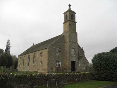
Eccles Parish Church
Volumes available for consultation within our Archive
Pre 1855 Memorial inscriptions of Berwickshire by David Cargill.
The Churches and Churchyards of Berwickshire by G.A.C. Binnie.
C.D. The Churches and Churchyards of Berwickshire by James Robson 1896.
Trotter of Prentonan by George Baird Trotter.
Index to Particular Register of Sasines for Berwickshire.
Pigot's 1837 Directory of Berwickshire and Roxburghshire.
Rutherford's Southern Counties Register and Directory 1867.
C.D. Slater's Directory of Berwickshire 1903.
County Directory of Scotland 1912 - Borders Towns and Villages.
Magazine Articles;
Please note that the heading Author includes persons who have compiled or transcribed records; and that the topics indexed, and the synopses are subjective opinions. See the Sales List to buy copies of the magazines containing articles in which you're interested.
Title
Synopsis
Size Description
Issue No
Author
A Cockburn Family in Berwickshire and Its Descendants - The Book
The author's Cockburn family history - mostly recent.
3 pages or more
24
Andrew Cockburn
Galashiels Murrays in New South Wales
Murrays first came to the fore in Eccles, follow them through generations. There is also a very touching letter in the article.
2 pages or more
10
Donald Wyte
Map of Eccles from UK Great Britain, Ordnance Survey one-inch to the mile (1:63,360), 'Hills' edition, 1885-1903 by kind permission of the National Library of Scotland. Use the control at the top left of the map to zoom in or out and drag the map left, right, up, or down as you wish.
Map of Eccles from UK Ordnance Survey Historical Maps from 1919-1947 by kind permission of the National Library of Scotland. Use the control at the top left of the map to zoom in or out and drag the map left, right, up, or down as you wish.
20 Most Common Surnames
The 20 most common surnames on gravestones recorded by us in the Eccles (with Birgham and Leitholm) monumental inscriptions volume are (number of gravestones in brackets): ROBERTSON (26), SCOTT (25), WOOD (25), WILSON (23), BELL (20), YOUNG (19), WALKER (18), BROWN (17), DICKSON (17), PURVES (16), TURNBULL (16), MCDOUGALL (16), ALLAN (14), JOHNSTON (14), JEFFREY (14), HENDERSON (14), SMITH (13), PATTERSON (13), STEWART (12), DODDS (11).
The Scottish Borders Archive and Family History Centre, The Hub Hawick hold the following records
Eccles School Board Minute Books ref; B/ED/1/40-42.
The Scottish National Archives Edinburgh contain the following records;
Eccles Parish Church;
Minutes 1721 to 1753 and 1832 to 1942.
Accounts 1721 to 1753 and 1813 to 1923 ref; CH2/910.
Eccles Free Church;
Minutes 1845 to 1919.
Communion Roll 1845 to 1894 ref; CH3/877.
Berwickshire Naturalists' Club has published the following
articles;
Vols. 7, 10, 16 and 36 Eccles Church.
Vols. 10 and 15 Eccles History.
Vol. 28 Drunfields, Dicksons, Gradens and Trotters of Eccles.
Vols. 30, 33 and 40 - visits.
Vol. 36 Ministers of the 17th. century.
Vol. 41 Eccles Parish School.
Vol. 41 Eccles, Printonan.
Vol. 42 Dr. George Johnston (1797 to 1855) by Dr. G.A.C. Binnie.
Websites;
Genuki has published a list of maps and plans available for consultation within the National Archives of Scotland.
The Statistical Accounts of Scotland compiled initially between 1791 and 1799, with a subsequent edition between 1834 and 1845 are a valuable record of the geography, history, economy, people and customs recorded by local ministers. You'll need to search for the parish name.