Gordon is centrally situated in the County of Berwick being bounded
on the north by the Parish of Greenlaw, on the east by the Parish of Hume, on
the south by the Parish of Earlston and on the west by the Parishes of
Legerwood and Westruther.
Old Parish Birth Records exist from 1652 to 1726 and from 1728 to 1854.
Marriage Records exist for the same periods.
Death Records exist from 1748 to 1753 and from 1784 to 1854.
1841 census Gordon.
1851 census Gordon.
1861 census Gordon.
Gordon, Nenthorn and Westruther Memorial Inscriptions edited by Elspeth Ewan
1999 (contains Hearth Tax, Militia List, List of Ministers and transcription of
the War Memorial). Gordon Deaths 1818-1854 by Nigel Hardie.
See our sales list for full details and cost of postage.
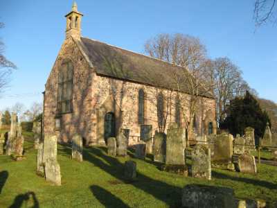
Gordon Parish Church
Volumes available for consultation within our Archive
Pre 1855 Memorial inscriptions of Berwickshire by David Cargill.
The Churches and Churchyards of Berwickshire by G.A.C. Binnie.
C.D. The Churches and Churchyards of Berwickshire by James Robson 1896.
Index to Particular Register of Sasines for Berwickshire.
Pigot's 1837 Directory of Berwickshire and Roxburghshire.
Rutherford's Southern Counties Register and Directory 1867.
C.D. Slater's History of Berwickshire 1903.
County Directory of Scotland 1912 - Borders Towns and Villages.
Magazine Articles;
Please note that the heading Author includes persons who have compiled or transcribed records; and that the topics indexed, and the synopses are subjective opinions. See the Sales List to buy copies of the magazines containing articles in which you're interested.
Title
Synopsis
Size Description
Issue No
Author
Maxwellheugh Cottage - the biography of a house
A review of the families who had inhabited a house on the outskirts of Kelso.
8 pages or more
73
Isobel Gordon
Memories of a Lost Border Railway
Review of the book Memories of across Border Railway by Bruce McCartney.
less than 1 page
94
Peter Munro
George Stuart Henderson VC; DSO and bar; MC
A commemorative flagstone is to be installed in Gordon where he was born. Born in 1893 of farmer Robert and Mary Henderson, he served with distinction with the Manchester Regiment throughout WW1. Funding for the flagstone is requested.
less than 1 page
104
Editor
Commemorating George Henderson
In Issue 104 (Oct/2020) there was a brief report on Captain George Henderson VC DSO and Bar. Born in East Gordon (1983), he served in the Manchester Regiment, and was killed in action in Mesopotamia in 1920. Post COVID lockdowns there is now a stone memorial to him in Gordon unveiled in July 2021.
less than 1 page
107
Editor
The battle of Otterburn 600th Anniversary
The history of the battle of Otterburn and the families that took part, also, Walter Scott's version is different to that of the English version in The Chevy chase.
2 pages or more
8
Violet Jardine
A Cockburn Family in Berwickshire and Its Descendants - The Book
The author's Cockburn family history - mostly recent.
3 pages or more
24
Andrew Cockburn
Hogarth Family Tree
Notes on a tree relating to the Hogarth family and dating back to the 17th. century donated to the Society.
less than 1 page
93
Travelling Scottish Sons from Ancrum, Crailing, Stichill and Earlston
Information extracted from the privately printed book about 3 large Border families, all of who had 1 girl who married a minister in each generations, where letters were written and kept by the brothers. The Cranstoun brothers to the Ancrum manse, the Scott brothers to the Stichill manse, and the Gordon brothers to Gordon and Earlston; the groups of brothers also kept in touch with each other. All these documents have been indexed and reflect every day life in the 1700s and early 1800s, including writing and social skills, education, professions and ministers tenures.
1 page or more
107
Colin -Miles Edgar
Anne Edgar
Cranston-Pringle-Spark
The author traces her genealogy.
1 page or more
94
Muriel Hall
Cranston Pringle Spark Update
Update on the Cranston Pringle Spark family, including photographs.
1 page or more
100
Muriel Hall
Soup Kitchen at Dunse 1832
An account of the outbreak of cholera in 1832 and minutes of the Dunse Committee of Health setting up soup kitchens with names of those to whom vouchers were issued.
3 pages or more
87
Ronald Morrison
Jethart Jock
A follow up to article in magazine no. 86 regarding the identity of Jethart Jock.
1 page or more
91
More Extracts from the Kelso Mail 1804
Some birth extracts from the Kelso Mail in 1804.
1 page or more
85
Map of Gordon from UK Great Britain, Ordnance Survey one-inch to the mile (1:63,360), 'Hills' edition, 1885-1903 by kind permission of the National Library of Scotland. Use the control at the top left of the map to zoom in or out and drag the map left, right, up, or down as you wish.
Map of Gordon from UK Ordnance Survey Historical Maps from 1919-1947 by kind permission of the National Library of Scotland. Use the control at the top left of the map to zoom in or out and drag the map left, right, up, or down as you wish.
20 Most Common Surnames
The 20 most common surnames on gravestones recorded by us in the Gordon, Nenthorn, & Westruther monumental inscriptions volume are (number of gravestones in brackets): HENDERSON (51), SCOTT (33), WOOD (24), ROBERTSON (22), MCDOUGAL (22), WILSON (22), PURVES (20), ALLAN (19), HOGARTH (19), BROWN (18), MURRAY (18), GIBSON (18), ANDERSON (17), WALDIE (17), JOHNSTON (17), HUNTER (17), PRINGLE (17), TROTTER (16), HAY (16), SMITH (16).
Scottish Borders Archives and Family History Centre, The Hub Hawick hold the following records;
Gordon Hospital Minute Book 1909 to 1930.
Gordon Schhol Board minutes 1873 to 1919.
The Scottish National Archives Edinburgh hold the following records;
1801,1811 and 1821 census records - ref CH2/457/2.
Gordon Parish Church;
Minutes 1652 to 1718 and 1818 to 1899.
Accounts 1690 to 1748 and 1753 to 1875.
Names of Heads of Families 1834 to 1842 - ref; CH2/457.
Gordon Free Church;
Roll of Children with Baptismal Dates.
Session Minutes 1844 to 1883.
Roll of Members 1843 to 1880.
Register of Deaths and Burials 1843 to 1887 - ref; CH3/165.
Berwickshire Naturalists' Club has published the following articles;
Vol. 9 Gordon - its Ministers.
Vol. 22 Gordon by the Rev. J Ritchie.
Vol. 28 Brumfields of Gordon.
Vol. 36 Ministers of the 17th. century.
Vols. 40 and 41 Gordon Parish School.
Websites;
First Statistical Account
by the Rev. Mr. Alexander Duncan (click "browse scanned pages" and insert Parish name).
RCHAMS website Scotland's Places contains details of;
Farm Horse tax 1797-1798.
Medical Officer's of Health Reports 1891.
Land Ownership Commission Report 1872 -1873. (available on CD in Society Archives).
Place and Farm names in Census Records;
1841 census: Gordon, Rumbletonlaw, Rumbleton, Bellitaw, Middlethird,
Hexpath, Max Mill, Mid Mill, Nether Mill, Byrewalls, Anchor Hill, Moors, West
Mains, Braefoot, Fawside, Greenknow, Easter Huntlewood, Wester Huntlewood,
Bents. 1851 census: Gordon, Mains, Gordon Moor, Hexpeth, Maxmill,
Fawside, Greenknow, Huntlywood, Anchorhill, Gordon Mill, Mid Mill, East Gordon,
Rumbletonlaw, Rumbleton, Bellataw, Middlethird, Byrewalls. 1861 census: Gordon, Huntlywood, Bents, Greenknowe, Little Ireland,
Maxmill, Rumbleton Law, Rumbleton, Hexpath, Fawside, East Mains, Gordon Mill,
Byrewalls, Anchorhill, Middlethird, Bellata.
Population;
The population has been recorded as follows:1755 - 737, 1791 - 912, 1801 -
802, 1811 - 851, 1821 - 740, 1831 - 882, 1841 - 903, 1851 - 983 1861 - 931.