This website uses cookies. To read more about them, click 'cookies stored'. To accept our cookies, click the check box then press 'Continue'.

| Us |
|
|
Parishes |
|
Websites |
|
On |
|
Our archive and search room is now open on Tuesdays and Thursdays from 10am to 4pm. Keep up to date via our Facebook page and Twitter.
|
Roberton is a rural Parish partly in the County of Selkirk and partly in the County of Roxburgh. It is bounded on the north by the Parishes of Ashkirk and Wilton, on the east by the Parishes of Hawick and Teviothead all in Roxburghshire, on the south by the County of Dumfries and on the west by the Parishes of Ettrick and Kirkhope. It is now part of Hawick Teviot ecclesiastical parish.
Old Parish Records cover the periods:
Sales List
|
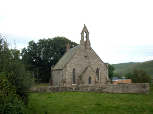
Roberton Parish Church
 |
See our sales list for full details and cost of postage.
Please note that the heading Author includes persons who have compiled or transcribed records; and that the topics indexed, and the synopses are subjective opinions.
See the Sales List to buy copies of the magazines containing articles in which you're interested.
| Title | Synopsis | Size Description | Issue No | Author |
|---|---|---|---|---|
| The Border Archive - For Queen and County | This is a list of all the men between the ages of 18 and 45 residing in Roberton in 1807. | 2 pages or more | 10 | Robert Miller |
| The Border Archive - For Queen and County | Militia list of all men between 18 and 45 residing in Roberton in 1807. | 2 pages or more | 13 | |
| The Miller Family of Hawick, Scotland and Delaware County, New York | This Miller family who emigrated from Hawick or Roberton-they set up a farm in the Catskill mountains of New York. | 2 pages or more | 34 | C. Raymond La Fever |
| Rev. Robert Douglas, 1747-1820 The father of Galashiels | The Rev. Robert Douglas, minister of Galashiels, 1747-1820, was a man of great ability and served his parishioners so well he was called "The Father of Galashiels". | 2 pages or more | 37 | Donald Whyte |
| Susanna Pringle's Birthday book | This Pringle tale goes from Browndeanlaw to Yetholm, London, New Brunswick and beyond-very interesting. | 4 pages or more | 16 | Maxine Flaherty |
| m Roxburghshire to Delaware County: The 19th Century Miller Letters - Part 1 | Account of letters written between 1818 and 1864 from Scotland to David Miller (1795-1883), and his wives, and relatives. David Miller was the son of Thomas Miller, a beadle of Roberton Kirk. | 4 pages or more | 64 | John W. Hoy |
Map of Roberton from UK Great Britain, Ordnance Survey one-inch to the mile (1:63,360), 'Hills' edition, 1885-1903
by kind permission of the National Library of Scotland.
Use the control at the top left of the map to zoom in or out and drag the map left, right, up, or down as you wish.
Map of Roberton from UK Ordnance Survey Historical Maps from 1919-1947
by kind permission of the National Library of Scotland.
Use the control at the top left of the map to zoom in or out and drag the map left, right, up, or down as you wish.
1841 census: Roberton, Ballendean, Alemoor, Parkhead, Borthwickbrae, Greenbanks, Howcleuch, Scaurnook, Roberton Woodfoot, Greenbanks, Hoscoatshiel, Hennywoody, Craik, Craik Shiel, Meadshaw, Philope, Deanburnhaugh Village, Mabonlaw, Borthwickshiels, Whitecleuchside, Harden & Hardenburn, Highchesters, Todshawhaugh, Whithope, Todshawhill, Chapelhill, Branxholme, Parkhill, Chisholme, Woodburn, Milsington, Broadlie, Muslie, Eildrige, Howpasley, Coom, Craikhope, Wolfcleughead, Outterside, Girnwood.
1851 census: Roberton, Borthwickbrae Haugh, Burnfoot, Alemoor, Greenbanks, Howcleuch Shiel, Roberton Woodfoot, Scaurnook, Hoscoat, Borthwickshiels, Ballindean, Meadshaw, Philope, Craik, Craikshiels, Henwoody, Deanburnhaugh Village, Mabonlaw, Whitecleuchside, Harden, Highchesters, Todsahwhaugh, Todshawhill, Whithope, East Branxholm, West Branxholme, Parkhill, Coom, Chisholme, Woodburn, Craikhope, Wolfcleughhead, Howpasley, Eildridge, Outterside, Girnwood, Muslee, Milsington, Shankfoot, Whapshaw.
1861 census: Greenbankhaugh, Scarnook, Glenburn, Borthwick Shiels, Howcleuch, Greenbanks, East Alemoor, West Alemoor, Borthwickbrae, Deanburnhaugh Village, Meadshaw, Craik, Henwoodie, Hoscote, Harden, Highchester, Todshawhaugh, Whithope, Chapelhill, East Branxholm, West Branxholm Loch, Parkhill, Woodburn, Milsington, Howplasley, Wolfcleuchhead, Craickhope, Eildrigg, Broadlee, Muselee, Girnwood, Whapshaw.
The population has been recorded as follows: