Our archive and search room is now open on Tuesdays and Thursdays from 10am to 4pm. Keep up to date via our Facebook page and Twitter.
Maxton
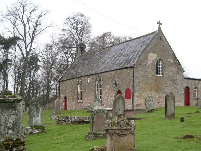
Maxton is a rural Parish in north Roxburghshire being bounded on the north by the Parishes of Mertoun in Berwickshire and Makerstoun, on the south-east by the Parish of Roxburgh, on the south-west by the Parish of Ancrum and on the west by the Parish of St. Boswells. Maxton & Mertoun parishes have been combined and they are now linked with St Boswells.
Memorial Inscriptions Vol 14 Roxburghshire by Elspeth Ewan 1994 - includes:
history
hearth tax
militia list
list of ministers
See our sales list for full details and cost of postage.
Volumes available for consultation within our Archive
Maxton 2000 by Charles Denoon - a detailed history of the Parish.
The Churches and Graveyards of Roxburghshire by Dr. G. A. C. Binnie 2001.
Rutherford's Southern Counties Register and Directory 1867.
County Directory of Scotland 1912 - Borders Towns and Villages.
CD-ROM Pigot's 1837 Directory of Berwickshire and Roxburghshire.
CD-ROM Land Ownership Commission Report 1872 -1873.
Magazine Articles
Please note that the heading Author includes persons who have compiled or transcribed records; and that the topics indexed, and the synopses are subjective opinions. See the Sales List to buy copies of the magazines containing articles in which you're interested.
Title
Synopsis
Size Description
Issue No
Author
War Records
Update on W.W.1 records being compiled by the Society.
less than 1 page
96
The relationship of place names and personal names
The relationship is two fold: (1) Place names derived from personal names,
(2) Personal names derived or adopted from place names.
1 page or more
21
Jessie Macdonald
Littledean Tower
A brief history of a little-known tower located at Ploughlands, about 1 mile east of Maxton (Grid Ref. 633313), near the disused quarry that supplied some of the stone for Melrose Abbey. Attacked in the Earl of Hertford in 1544, the tower was the chief residence of the Kerrs of Cessford.
less than 1 page
102
Margaret Dick
From Cowal to the Borders. Internal migration of the Whyte Family
The Agricultural migration of workers and the history of the Whyte Family.
2 pages or more
7
Donald Whyte
The Lillico Family - Chain Migrants to Gloucester Township, Ontario
The story of a family that emigrated from Roxburghshire to Ontario
8 pages or more
70
Eleanor Lillico
Map of Maxton from UK Great Britain, Ordnance Survey one-inch to the mile (1:63,360), 'Hills' edition, 1885-1903 by kind permission of the National Library of Scotland. Use the control at the top left of the map to zoom in or out and drag the map left, right, up, or down as you wish.
Map of Maxton from UK Ordnance Survey Historical Maps from 1919-1947 by kind permission of the National Library of Scotland. Use the control at the top left of the map to zoom in or out and drag the map left, right, up, or down as you wish.
20 Most Common Surnames
The 20 most common surnames on gravestones recorded by us in the Maxton monumental inscriptions volume are (number of gravestones in brackets): THOMSON (19), SCOTT (10), WIGHT (6), DAVIDSON (5), WOOD (5), GRANT (5), TURNBULL (4), ROBSON (4), BROWN (4), LYALL (4), BELL (4), LAUDER (4), FIDDES (3), ROBERTSON (3), YOUNG (3), SIMPSON (3), DOUGLAS (3), RICHARDSON (3), HENDERSON (3), BURNS (3).
Two Centuries of Borders Church Life by J Tait Kelso 1891.
The Statistical Accounts of Scotland compiled initially between 1791 and 1799, with a subsequent edition between 1834 and 1845, are a valuable record of the geography, history, economy, people and customs recorded by local ministers. You'll need to search for the parish name.