Our archive and search room is now open on Tuesdays and Thursdays from 10am to 4pm. Keep up to date via our Facebook page and Twitter.
Makerstoun
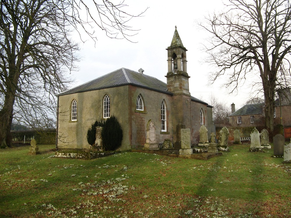
Makerstoun is a small Parish in north east Roxburghshire being bounded by the Parishes of: Smailholm on the north, Kelso on the east, Roxburgh on the south and Maxton and Mertoun in Berwickshire to the west. Makerstoun is now one of the Kelso Country Churches - the others are Nenthorn, Roxburgh, Smailholm & Stichill - which is linked with Kelso Old Parish Church & Sprouston.
Monumental Inscriptions No 9 Roxburghshire 1994 edited by Elspeth Ewan - includes:
Hearth Tax
List of ministers
War Memorial transcription
Notes on Fasti Ecclesiae Scoticanae
See our sales list for full details and cost of postage.
Volumes available for consultation within our Archive
The Churches and Graveyards of Roxburghshire by Dr. G.A.C. Binnie 2001.
Rutherford's Southern Counties Register and Directory 1867.
County Directory of Scotland 1912 - Borders Towns and Villages.
The Makerstoun Minstrel - Dr. George Paxton by A.T.R.The Southern Annual, 1957 .
CD-ROM Pigot's 1837 Directory of Berwickshire and Roxburghshire.
CD-ROM Land Ownership Commission Report 1872 -1873.
Magazine Articles;
Please note that the heading Author includes persons who have compiled or transcribed records; and that the topics indexed, and the synopses are subjective opinions. See the Sales List to buy copies of the magazines containing articles in which you're interested.
Title
Synopsis
Size Description
Issue No
Author
Rob of Trows
Born at Birgham, Rob was a favourite with anglers of all classes, "peer and peasant alike". A boatman of great distinction on the Tweed.
2 pages or more
18
Mrs M. E. Mason
The relationship of place names and personal names
The relationship is two fold: (1) Place names derived from personal names,
(2) Personal names derived or adopted from place names.
1 page or more
21
Jessie Macdonald
Sir Thomas Brisbane - His Link with the Borders
From a request to Kelso Museum for details on Sir Thomas Brisbane. A history of Makerston and the City of Brisbane He was also a keen astronomer. Very interesting.
2 pages or more
8
Zilla Oddy
Thistle and Shamrock
A very well researched article on family history covering Rutherford, Brown, Atkin, and more. The Irish connection would make it very difficult.
2 pages or more
9
John L. Alton
Rob of Trows
A very prince of a Tweed boatman. That was the description of Rob by Sir Robert Maxwell in his Book "The Story of the Tweed".
2 pages or more
19
Map of Makerstoun from UK Great Britain, Ordnance Survey one-inch to the mile (1:63,360), 'Hills' edition, 1885-1903 by kind permission of the National Library of Scotland. Use the control at the top left of the map to zoom in or out and drag the map left, right, up, or down as you wish.
Map of Makerstoun from UK Ordnance Survey Historical Maps from 1919-1947 by kind permission of the National Library of Scotland. Use the control at the top left of the map to zoom in or out and drag the map left, right, up, or down as you wish.
20 Most Common Surnames
The 20 most common surnames on gravestones recorded by us in the Makerstoun monumental inscriptions volume are (number of gravestones in brackets): WILSON (8), HAY MAKDOUGALL (6), SCOTT (6), FAIRBAIRN (5), OLIVER (5), MURRAY (5), GRAY (4), BROWN (3), RUTHERFORD (3), PATTERSON (3), LAWSON (3), PATERSON (3), JOHNSTON (3), THOMSON (3), SHEPHERD (2), CHISHOLM (2), FOSTER (2), DAVIDSON (2), JOHNSTONE (2), HENDERSON (2).
Two Centuries of Borders Church Life by J Tait Kelso 1891.
The Statistical Accounts of Scotland compiled initially between 1791 and 1799, with a subsequent edition between 1834 and 1845 are a valuable record of the geography, history, economy, people and customs recorded by local ministers. You'll need to search for the parish name.