Our archive and search room is now open on Tuesdays and Thursdays from 10am to 4pm. Keep up to date via our Facebook page and Twitter.
Sprouston
The Parish of Sprouston, which includes the village of Lempitlaw, is situated in east Roxburghshire on the border with England. The Parish of Ednam is to the north, the English county of Northumberland is on the East, the Parish of Linton is on the south and the Parishes of Eckford and Kelso are on the west.
Monumental Inscriptions, Roxburghshire: Vol IV Sprouston and Lempitlaw edited by Elspeth Ewan 1992 (reprint 2001)- includes:
Hearth Tax
Militia List
War Memorial transcription
List of ministers
CD-ROM Kelso Poor Law and Ragged School Records.
See our sales list for full details and cost of postage.
Volumes available for consultation within our Archive
Reminiscences of Early Life in the Valley of Lempitlaw in the Borders of Scotland by Thomas Scott 1987.
A Bunch of Sweet Peas by the Rev David Fraser.
The Churches and Graveyards of Roxburghshire by Dr. G.A.C. Binnie 2001.
Rutherford's Southern Counties Register and Directory 1867.
County Directory of Scotland 1912 - Borders Towns and Villages.
Index to Kelso Chronicle Death Notices 1853 by Vivienne Dunstan.
Index to Kelso Chronicle Death Notices 1854 by Vivienne Dunstan.
CD-ROM Pigot's 1837 Directory of Berwickshire and Roxburghshire.
CD-ROM Slater's Directory of Southern Scotland 1878.
CD-ROM Land Ownership Commission Report 1872 -1873.
Magazine Articles
Please note that the heading Author includes persons who have compiled or transcribed records; and that the topics indexed, and the synopses are subjective opinions. See the Sales List to buy copies of the magazines containing articles in which you're interested.
Title
Synopsis
Size Description
Issue No
Author
Two Stories of 19th Century Emigration to Australia and New Zealand - The Haliburtons of Sprouston
Origins of the Haliburtons; William who had 12 children and their emigration to New Zealand.
less than 1 page
12
D.N. Haliburton
The Trotters of Sprouston and Hadden - Part 1
Absorbing account of the author's researches into her Trotter ancestry.
7 pages or more
52
Jenny Fairman
The Trotters of Sprouston and Hadden - Part 2
Absorbing account of the author's researches into her Trotter ancestry.
5 pages or more
53
Jenny Fairman
Following in the Footsteps of Robert Redpath.
The story of one man's journey to mine gold in Australia. There is reference to two diaries kept by other men on the voyage from Glasgow to Townsville, Queensland.
3 pages or more
69
Irene J Redpath
Sister Elizabeth Tully
Some notes on the book, 'A Nurse at the Front' being effectively the transcript of a Diary kept by a WW1 nurse, Sister Edith Appleton.
less than 1 page
97
Map of Sprouston from UK Great Britain, Ordnance Survey one-inch to the mile (1:63,360), 'Hills' edition, 1885-1903 by kind permission of the National Library of Scotland. Use the control at the top left of the map to zoom in or out and drag the map left, right, up, or down as you wish.
Map of Sprouston from UK Ordnance Survey Historical Maps from 1919-1947 by kind permission of the National Library of Scotland. Use the control at the top left of the map to zoom in or out and drag the map left, right, up, or down as you wish.
20 Most Common Surnames
The 20 most common surnames on gravestones recorded by us in the Sprouston & Lempitlaw monumental inscriptions volume are (number of gravestones in brackets): TURNBULL (29), SCOTT (16), TROTTER (15), DAVIDSON (14), WALKER (14), THOMSON (13), BROWN (12), WILSON (12), ANDERSON (12), GIBSON (11), ROBERTSON (10), CAIRNS (10), BRUCE (10), GRAY (10), TULLY (10), AITCHISON (10), WRIGHT (10), FAIRBAIRN (9), MURRAY (9), RUTHERFORD (8).
Two Centuries of Borders Church Life by J Tait Kelso 1891.
The Statistical Accounts of Scotland compiled initially between 1791 and 1799, with a subsequent edition between 1834 and 1845 are a valuable record of the geography, history, economy, people and customs recorded by local ministers. You'll need to search for the parish name.
Lempitlaw School Admissions Register 1934 to 1961 (Ref - R/ED/3/22).
School Log Book 1877 to 1937 (Ref - R/ED/2/56).
Haddon School Log Books 1886 to 1937 (Ref - R/ED/2/23-24).
The National Archives of Scotland, Edinburgh
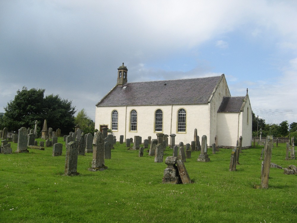
Sprouston Parish Church
Births 1855 to 1902.
Minutes 1650 to 1656, 1662 to 1673, 1691 to 1700, 1709 to 1712, 1722 to 1769 (with accounts), 1731 to 1798 (financial) 1770 to 1816 (with accounts) and 1817 to 1873.
Accounts 1753 to 1788, 1774 to 1832, 1816 to 1857 and 1851 to 1885.
Poors' Accounts and Minutes 1752 to 1771, 1780 to 1803 (includes Heritors' Minutes).
Young Communicants etc. 1836 to 1876.
Certificates 1812 to 1845.
Account of Poor's Mortified Money in the Barony of Haddon 1782 to 1829.