Our archive and search room is now open on Tuesdays and Thursdays from 10am to 4pm. Keep up to date via our Facebook page and Twitter.
Southdean and Abbotrule
Southdean is an upland Parish in the south of Roxburghshire on the border with England which was sometimes known as Charteris Parish. On the western boundary is the Parish of Hobkirk to the north and east lies the Parish of Jedburgh, the Parish of Edgerston lies to the east, the English County of Northumberland runs along the southern boundary whilst the Parish of Castleton lies to the south west.
According to the Gazetteer of Scotland, Edinburgh, 1806 - "Like the rest of the border districts, this parish affords many monuments of warlike antiquity, as camps, castles, and other fortifications".
The former Parish of Abbotrule (occasionally Abbotsrule) was suppressed in 1806 and divided between Southdean and Bedrule.
Southdean & Abbotrule and Hobkirk are now linked with the Parish of Ruberslaw (a combination of the former Parishes of Bedrule and Minto).
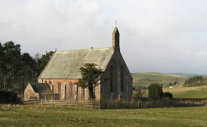
Southdean Parish Church
Old Parish Records for Southdean cover the periods:
Southdean Mortcloth Records 1736 to 1758 by Nigel Hardie.
Southdean Burials 1818 to 1844 by Nigel Hardie.
See our sales list for full details and cost of postage.
Volumes available for consultation within our Archive
Ruleswater and its People by George Tancred - reprint 1992.
The Churches and Graveyards of Roxburghshire by Dr. G.A.C. Binnie 2001.
Rutherford's Southern Counties Register and Directory 1867.
County Directory of Scotland 1912 - Borders Towns and Villages.
CD-ROM Pigot's 1837 Directory of Berwickshire and Roxburghshire.
CD-ROM Land Ownership Commission Report 1872 -1873.
Magazine Articles
Please note that the heading Author includes persons who have compiled or transcribed records; and that the topics indexed, and the synopses are subjective opinions. See the Sales List to buy copies of the magazines containing articles in which you're interested.
Title
Synopsis
Size Description
Issue No
Author
The Olivers of Jed Valley
A History of the Olivers of the Jed Valley tracing their history from the earliest of times with reference to some of the more famous and infamous.
6 pages or more
85
Norrie McLeish
The Lillico Family - Chain Migrants to Gloucester Township, Ontario
The story of a family that emigrated from Roxburghshire to Ontario
8 pages or more
70
Eleanor Lillico
Map of Southdean from UK Great Britain, Ordnance Survey one-inch to the mile (1:63,360), 'Hills' edition, 1885-1903 by kind permission of the National Library of Scotland. Use the control at the top left of the map to zoom in or out and drag the map left, right, up, or down as you wish.
Map of Southdean from UK Ordnance Survey Historical Maps from 1919-1947 by kind permission of the National Library of Scotland. Use the control at the top left of the map to zoom in or out and drag the map left, right, up, or down as you wish.
20 Most Common Surnames
The 20 most common surnames on gravestones recorded by us in the Southdean & Abbotrule monumental inscriptions volume are (number of gravestones in brackets): OLIVER (38), SCOTT (26), TURNBULL (24), DOUGLAS (11), TELFER (11), ROBSON (8), RUTHERFORD (8), SHIELL (7), THOMSON (7), ARMSTRONG (7), ELLIOT (7), SMITH (7), MURRAY (7), HEDLEY (7), DAVIDSON (7), BELL (5), THOMPSON (5), STEWART (5), OLIPHANT (5), RENWICK (5).
Other Sources
Annals of the Free Church of Scotland, 1843 to 1900 by the. Rev. William Ewing
contains details of the Free Church of Scotland Wolflee Congregation which served the Parishes of Southdean and Hobkirk.
The Statistical Accounts of Scotland compiled initially between 1791 and 1799, with a subsequent edition between 1834 and 1845 are a valuable record of the geography, history, economy, people and customs recorded by local ministers. You'll need to search for the parish name.
Two Centuries of Borders Church Life by J Tait Kelso 1891.